Touring Europe 2013
Part 2, Turkey
INTO TURKEY
Monday 10 June
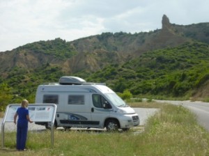
Peaceful night, once Norma had requested a talkative group of nearby Italian neighbours to quieten down a bit! Then away and a quite pleasant run of only about 60 km on quiet roads through far-east Greece and to the long-anticipated border with Turkey.
Waved easily out of Greece with only a cursory look at our passports, then a drive of a few kilometres through no-man’s-land to Turkey. Here, things got more complicated, and we were greatly assisted by the advice given by an old Turkey hand on his blog. First, we stopped at a small duty-free shopping centre where, by finding the only office we could not identify as something else, we obtained the mandatory third-party vehicle insurance. This, we had been unable to obtain through our Australian/UK insurance agents – vehicle insurance in Europe of any kind for EU non-residents is very hard to obtain. But we got legal for Turkey for the low sum of €55, as the man kindly classified our vehicle as a “van” rather than as a “motor caravan” as given in the UK registration documents.
Next we had to obtain visas. People waved us towards the police station, and they in turn directed us to one of the kiosks past which we would eventually drive. The visas cost €15 each, proving that the ways of officialdom remain incomprehensible – my visa when entering for the FIA conference in Istanbul last December cost €45. Maybe they just slug arrivals by air.
Visa stamps stuck into our passports and insurance obtained, we were then permitted actually to start the entry process. Back to the van, and drove to another kiosk. Here, the man inspected all the paperwork, punched all the vehicle data into another computer, rubber-stamped the visa, and entered the van into my passport, so that I could not leave the country without it (a reason why I cannot go to the June set of FIA safety research meetings). We got three months to stay, but the van got over six months. Go figure, as the Americans say. Finally, with everything stamped, another 100 metres to yet another kiosk, where all the paperwork was examined yet again, and we were allowed to go. We
were fortunate that we appeared to be the only private vehicle going through at the time. We felt sorry for the truckies, who went mostly through their own lanes having queued for ages and being subject to much more paperwork and vehicle examination.
All this was strongly reminiscent of our experience in 1988, when we cruised Turkish waters in our yacht Cera. About the only difference was that in harbours the offices were further apart, and there were port and medical authorities to cope with as well. There is a lovely word in ancient Turkish, adamsendecilik, which means “being messed about in a pointless way by someone in authority, to the point at which you need help”.
Anyway, after three-quarters of an hour or so, here we were in Turkey. The topography was flat and brownish, not interesting at all, and we scooted along the motorway through Thrace with only one unpleasant distraction. It was hard to find anywhere to stop for lunch, as there appeared to be no designated parking places along the motorway, which was undergoing substantial rebuilding. But we spotted a track entering a pine forest, and went just far enough along it to get clear of the motorway, although still quite close. We got ourselves settled for our usual light lunch on our table within the living area of the van, and had started it when there was a knock on the driver’s door, of which the window was open. A gap-toothed, unshaven and thoroughly unsavoury-looking man stuck his head in, motioning that he wanted a cigarette and speaking in a tongue we did not recognise. He continued to gesture and make requests, including for drink and food, and to our dismay opened the door. I quickly moved across to remove the ignition key and take up my wallet, which was on a shelf under the steering wheel. I suggested we give him a sandwich and, by saying “bye-bye”, he would go away. No such luck, and Norma told me later that he had exposed himself to her while I was trying to secure everything.

Kabatepe information centre and museum
We finally managed to get the doors locked and the windows shut, and drove away with some relief. A disturbing and unsettling experience which we have never had before, and think it should not colour our view of Turkey at this early stage. The fact is we were still very close to the border, and thousands of illegals from the Caucasus and the Middle East are trying to get into Greece and thence other EU countries. We thought he was probably one such, meanwhile hiding in the forest. Being obviously a shilling short of a quid, it is unlikely that he would ever make it. I try to feel sorry for him, without much success I fear.
As so often happens, a few kilometres down the road we came across a perfectly acceptable parking place outside a cafe, where several had stopped for a picnic.
Our very general strategy is to make an anticlockwise loop round Turkey, so the first step was to turn south off the Istanbul road and head down the Gallipoli peninsula. We visited the new Kabatepe Information Centre, one of the several museums covering the peninsula’s role in WW1, with lots of audiovisual gadgetry involving moving floors, flashes and bangs, and 3-D glasses. They were trying just a little too hard, we thought, with a storyline that was hard to follow but an emphasis I’ll return to.
From there a search for a place for the night, having had no idea earlier in the day where we would end up. The closest camp site was closed, so we then followed signs to another that we had read about, Camping Hotel Kum. This turned out to be a very pleasant site among olive trees in the grounds of a fairly recently renovated and rebuilt hotel complex. It was quite busy when we arrived, with 10 or more British in vans and caravans just coming to the end of a group tour of Turkey, as were several from Holland in another group.
Tuesday 11 June
Decided that we could slow down and take a lay-day, so stayed put, only taking a walk down to the beach area for a look at a large number of turtles in a closed-off waterway. The weather remains very pleasant, not too hot, with a light breeze and some clouding over by late afternoon. Mainly caught up with reading on the history of Turkey and researching possible stopping places.
Wednesday 12 June
Got windy overnight, with a light shower and a rumble of thunder. Much cooler in the morning, with 80% white overcast. Caught up with the internet on the way out and set off for our tour of the Gallipoli battlefields. We had visited before, briefly, when we had rented a car for a week during our cruising days in 1988, but this time we were much better prepared and researched.
The first thing to get your head round in these parts is how on earth it came to pass that young Australians and New Zealanders had come half way round the world to find themselves fighting against Turks? Was the war not the British Empire versus Germany? Truly, WW1 started in 1911 and did have its roots in Turkish affairs. Following the fall of the last Ottoman sultan in 1909 and the emergence of the largely secular liberal Young Turk movement (shades of what’s now happening in Istanbul and Ankara), government of the new nation became something of a shambles. A surge in Turkish nationalism was stimulated by an army coup in 1913, but political turmoil continued because all the countries surrounding the collapsing Ottoman Empire saw their chance to grab a part of it: France in Morocco, supported by the British but opposed by the Germans; Italy in Libya and the Aegean islands; Greece, Serbia, Albania and Bulgaria in the Balkans.
Thus started in 1912 the Balkan wars, to the alarm of the Great Powers. Ottoman surrenders resulted in immense waves of refugees, some massacres, and long-lasting hatreds. Those wars ceased in 1913 but in the east, the Ottomans were faced by insurgencies among the large Armenian and Kurdish populations, threatening a total collapse of the empire. The Young Turks sought the help of a German military mission to help with their army, but this was a real worry for Russia, whose immense grain export trade and strategic considerations required free access to and through the Straits of Canakkale, or Dardanelles. To the Germans the Russian Bear appeared to be on the brink of a takeover of the region.
In Germany, the generals demanded war with Russia before it was too late – but what of an excuse? The heir to Austria-Hungary was then shot by a Serb terrorist in Sarajevo. The Germans told their Austro-Hungarian allies to take revenge on Serbia. Russia mobilised in protection of Serbia and their position in the Balkans. Berlin duly declared war on Russia, France mobilised, and the Germans invaded Belgium. The British were thus dragged in, and the flag for WW1 was dropped in 1914. None of this had a great deal to do with young farmers in Dubbo or labourers in Woolloomooloo.
The Turks went into alliance with Germany, with a view to establishing their independence and place in the world. They were loaned two German warships, which were sent to bombard Odessa, Russia’s Black Sea port. So, Turkey was by now at war with Britain, France, Russia and Italy, who went about discussing how they would divide up Turkey after the war they would win – exactly the outcome the whole Turkish affair was intended to prevent.
But what happened was an extraordinary recovery for Turkey and its nationalist ideals. Churchill thought that Turkey would collapse if the British navy took over the Dardanelles. In 1915 12 battleships were sent into the Straits, but heavily damaged by shore batteries and well-laid mines and had to withdraw. Plan B was a landing on the Aegean coast of the Gallipoli peninsula and securing the Turkish batteries from the west. And this is where we came in, as the boys of Australia and New Zealand joined the other boys of the British Empire in a great adventure.
The Australian view and history of the Gallipoli battles is well known and documented. What came through to us on this visit is how very strongly the Turkish people see the battles as a victorious defence of an invasion of their homeland and a cementing of their nationalistic ambitions. Mustafa Kemal – a key officer in the Gallipoli battles and later the first President of Turkey – was, indeed, one of the founders of the Young Turks movement. In the Information centre at Kabatepe we were in the company of a large number of Turkish students, the girls almost all being dressed quite traditionally, with head scarves and ankle-length garments. The emphasis in the series of AV displays was the undeniable heroism of the Turkish soldiers, the victory of the nation and establishment of its future, and – outspokenly and rather unexpectedly – the defence of Islam.
Anzac Cove, with “The Sphinx” on the hill
On the Turkish side, the battle was declared by the Sultan a jihad – a holy war. The fighting broke out on the Feast of the Sacrifice, and it was understand by the soldiers that they were to be the lambs. They became intoxicated by the idea of martyrdom, as the imams told them that if they died in a holy war they would meet the Prophet, name seventy people they would like to take to Paradise with them, and have seventy-two virgins to wait on them and do their pleasure. Indeed, a daunting enemy for the Anzacs to face! And in the latter respect, this sexist benefit should sit ill with Islamic believers who keep their earthly relatives covered up and away from sin, accountable only to their male relatives.
Back to Gallipoli, this Turkish view of the battles was reflected in the relatively high number of Turkish visitors – in large numbers of coaches – to the battlefields of great Turkish significance and the relative lack of interest in places treated with reverence by visitors from the old “Empire”, including Australians. We had Anzac Cove and its surroundings virtually to ourselves. There is now a large open space at Long Beach, just north of Anzac Cove and from which landings were also made, where the Anzac Day memorial services are held. Along a wall separating part of this area from the road that runs through it there is an excellent array of panels, in English and Turkish, describing the Gallipoli campaign from the point of view of both combatants, with due regard to the heroism of both sides.
 We are aware of the controversy surrounding “development” of the whole area to support the growing number of visitors, but saw it as well done, considering the problems. The road has required shoring up on the sea side, so there is a wall supporting it along Anzac Cove. But remembering our visit 25 years ago, we found no change in the feelings and emotions that arise from wandering round these battlefields.
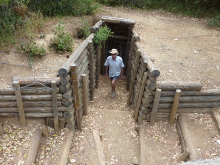
In a more practical sense, a new one-way well-surfaced route round the battlefields and cemeteries of the high grounds and ridges – Lone Pine, the Nek, Quinn’s Post, Chunuk Bair and the rest – are far easier to access than when we were here before. Each important site has a good explanatory panel in English and Turkish, and places that can be missed, such as the remains of trenches, are clearly identified. As is well known in theory, but awe-inspiring when you stand there, in some places the opposing trenches are only a few metres apart: just the width of the new road, in fact, at the narrowest part of the ridge along which it runs.
It’s so ironic that following what was to some extent a side issue once WW1 had got going in northern Europe is now seen by the Turkish people as a glorious victory that placed their country as prominent among the family of nations; just as, in contrast, in Australia its part in the Empire’s honourable defeat and withdrawal is similarly viewed as a defining event in its history. What warms the heart is that as we wandered through the small Australian cemetery at Anzac Cove, a young Turkish man in a group said to me, “you are welcome, sir”.
From the Gallipoli peninsula we then needed to cross over the Straits, which was by way of a ferry from Eceabat to Canakkale. This runs hourly, and while to regulars it would be a routine, to visitors it seems a bit of a shambles. But we got on OK, squeezed into an unnecessarily small slot, and emerged into the heavy aggressive traffic of the big town of Canakkale. We need to get some money and do some shopping for supplies, but parking would have been impossible, so we headed out of town in the hope that something would turn up. It did, on the outskirts as is usual, as the huge Kipa supermarket appeared. Turns out that Kipa is part of the Tesco empire, new invaders of Eastern Europe. It was a fairly conventional “hypermarket”, with foodstuffs comprising quite a small proportion of the whole.
Following our experience on the first day we were still a bit edgy about free camping, so we found a tiny site close to Troy, close to the coast of the northern Aegean. It is part of a small pension/restaurant complex, and we had beers (local Efes “Malt”, better than the standard Efes) and a light dinner there, talking to the owner, a guide for the ruins of Troy.
A vicious thunderstorm later, as is still common in the region, but not as much rain as we expected.
Thursday 13 June
Cooler again after the change, sunny in part of the sky and black clouds and thunder in another. Meanwhile, we read that Taksim Square in Istanbul now resembles a battle zone and four people have died, despite Erdogan’s attempt to hold talks with rebels – while also advocating a harder line! A Kiwi we met last evening, who has just been staying in Istanbul, says you would never notice anything was happening, anywhere else in the city. The President is reportedly supporting a softer line than Erdogan.
We paid scant attention to Troy. We have been there before, and from what we know now, the ruins are as mixed up and complicated as ever. There are several layers excavated (some say 47), each with a Troy number. Homer’s Troy is probably Troy VI, about 1275 BC, but debate continues. Without Homer’s epic poems the Iliad and the OdysseyI (oh, the Latin readings at school!), Troy and its ruins would have long been forgotten. Homer describes a mighty city, but the reality is that it was never more than a royal citadel, a palace with a small surrounding population. A dreadful reconstruction of a wooden horse with a shed on its back (Google an image) now does nothing to enhance its reputation.
South again, through increasingly bad weather: thunderstorms and heavy rain. We sought a waterside stopping place, perhaps for the night, somewhere near the ruins of Assos. In ancient Assos Aristotle founded a school of philosophy in 340 BC, but little remains and the ruins were closed. Down a precipitously steep and narrow road lies the little harbour of Behramkale, where “camping” was offered. In a bad decision we dived on down and just managed to get through the narrow harbourside streets, restaurants and a wedding, being waved on by smiling Turks. At the far end of the village we entered a tiny yard (“yes, camping!”, we were encouraged by the owner) within which we feared we would never be able to turn round and leave. To the disappointment of the owner, and after we had had to move several piles of timber, we managed a hundred-point turn, negotiated back through the village and climbed the hill up to a bus parking place to stay the night (another “camping”, apparently) for $5.
What is now clear that every little restaurant with a space next to it promotes it as “camping” in the hope that folks like us will stay there and, hopefully eat there too. Not that there is any pressure, and we find the Turks most friendly, trying always to be helpful.
The view over the northern Aegean to the Greek island of Lesbos was lovely, and we hoped the sun would soon shine again.
Friday June 14

Behramkale Harbour
Quiet night, fine sunny morning, with white clouds. Walked down to the village this time, a very attractive little place, the little harbour backed by several rather grand-looking old buildings, all now hotels. Few people staying this time of the year, having breakfast on waterfront tables.
On the way out, stopped to admire the good Roman amphitheatre of ancient Assos – the large site is not closed as we thought, but open to free access through rusty revolving gates. Took a seafront scenic route east for a while, through long stretches of tourist developments, locally oriented, ranging from luxurious-looking hotels to boring condominium complexes, interspersed with very poor-looking dwellings and “camp sites” (rough fields with lean-to tents). Rough little road, too, but better once back on the main highway south along the north Aegean coast.
Looped around the eastern end of Edremit bay, still not very attractive surroundings: long strings of development, factory units, shops and megamarkets, open flat land soon to be developed. But the hazy hills of the Kazdagi range always up on our left.
Parking place, overlooking village outside Bergama
We had been aiming to stop and have a look round Ayvalik, but this attractive-looking town was very busy, with a large harbour for both pleasure and working vessels, including shipyards, and was thus very difficult to stop in. Not to speak of the chaotic traffic, typical in a town of any size, we have found. So we pressed on towards Bergama, by this time in countryside, heavily featuring immense groves of olives, with their number still being increased on what seemed to be artificially constructed slopes. Unsurprisingly, this a major centre for olive oil production, and there were several stands selling oil by the roadside.
At the top of a steep hill just outside Bergama is the important acropolis of Pergamum, first settled in the 8th century BC. We were aiming to stop at a camp site on the approaches to the town, the only one to our knowledge, but on having a look it was packed out entirely by an Italian motorhome touring group. Apart from being almost completely full, we decided to move on because our experience of Italian campers in a group is that they are cheerfully noisy well into the night!
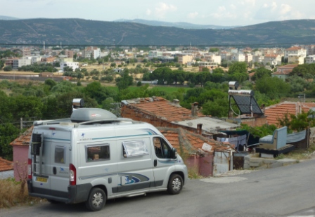
We thought we would look for a safe-looking car park, but after checking out a couple drove up to the small parking area along the road at the bottom of the cable car that in recent times takes visitors up to the site. The sign said that the strip was for buses and campers only, and the helpful wee man said we could spend the night there for 17.50 Turkish lira ($10 AUD). That was fine by us.
Now, by 8:00 pm, picture this. This “parking place” is essentially a road winding up the hillside. The buses and all other vehicles have gone. On the upper side of the road is the base station for the cable car. On the lower side is a very simple Turkish village, and from our elevated position we can see straight down into the back yard of one of the houses. The chickens are running around, guarded by a small dog on a tether. Children are gathering dead grass along the road and around the van to feed something or other we have not seen, but we have heard a sheep and a cow. A small boy pokes his hand through the window to be shaken and says hallo. A little girl on a rooftop lets the pigeons out to walk around. (What are they for? Eating? Probably.) Folk looking older than they are, are hobbling along the road from place to place. A horse is taken for a walk up the hill beside the cable car and is left up there to feed. Families are out for what in Spain is called a paseo.
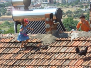 The road has become a playground not only for children but also older boys on motor scooters, whose behaviour threatens the life and limb of not only their passengers but also most of the younger and older villagers, cats and dogs too; no one seems to mind. Sheep graze on the grass in front of the steel-and-glass front of the cable car station. To our horror we saw a little girl of about 10 sent up on a steeply-pitched roof to chase off a chicken that had made its way up there. Overlooking a five-metre drop, she cheerfully trotted over the tiles, waving her arms. We feel around us Turkish life as she is lived. “Safety” is a secondary issue.
Unfortunately, village life became too real after 9:00 pm as the tethered dog began insistent barking, setting off all the neighbourhood dogs, and after two hours of this and no prospect of sleep we moved along the road to where the buses park in search of a quiet night.
Saturday 15 June
Which we got. Another benefit of the move was to put distance between us and the loudspeaker broadcasting the call to prayer, an amplified waterfall of tuneless chant to our ears. It happens all over the country at slightly varying times defined by the Muslim faith, but includes 11:00 pm and 4:30 am or thereabouts, which is inconvenient.
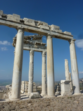
Trajan’s Temple, on Acropolis at Pergamum
The importance of the Pergamum settlement is that it was established and made rich by one of Alexander’s generals, Lysimachus, who captured most of the Aegean region after Alexander’s empire fell apart in 323 BC. Just over 100 years later Eumenes II added to the existing Acropolis, founded one of the world’s greatest libraries, and expanded the scope and the work of the Asclepion, an ancient medical centre where the influential Galen set up shop as physician to Pergamum’s gladiators. The complete settlement included what is now the unattractive town of Bergama, and what most visitors come to see is the city’s Acropolis, perched high on the nearby hilltop.
It is possible to drive up to a small car park near the summit, but it is discouraged, and a ride in a “dolmus” minibus costs next to nothing. And the German-built cable car, which is more fun, costs only about $5 return. The view expands on the ride up, and is outstanding from the top. It is easiest then to walk on further up and start the visit by wandering round the Temple of Trajan, built during the years of the emperors Trajan and Hadrian.
When we visited in 1988 we commented on, and took a picture of, the adjacent theatre. There is good reason to, because it is built on the side of the precipitous hillside, so it is exceptionally tall, steep and narrow compared to most ancient theatres. Visitors can’t explore it – like theatre-goers of the time, there’s a long way to fall to the stage. The only comment we made at the time was to say that we saw the foundations and ruins of the temple.
Meanwhile, German archaeologists have made an astonishing job of a partial reconstruction of Trajan’s temple. The philosophy and technique they adhered to has a Greek name that I’ve forgotten, but essentially what it means is that every piece of the jigsaw of parts, building blocks and rocks has to be in its perfect place, with its neighbours of a thousand years ago. If it don’t fit, it returns to store or the ground. With what they did have, and manage to fit together, makes it well possible to see how the Temple of Trajan was: a colonnaded centrepiece, surrounded by a courtyard enclosed by another rectangular set of columns.
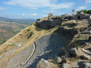
Steep theatre at Pergamum
The complex includes several other smaller temples and altars, as well and the foundations of several royal palaces. This was not a place for ordinary people to live; that was down in what is now the town of Bergama.
Off then on a rather trying drive, mostly through drear industrial suburbs, becoming busier as we approached Izmir, the third largest city in Turkey. We circled the city, and were amazed by the scale of building: vast areas completely covered by large apartment blocks. The industry here is clearly one of the several pumps driving Turkey’s rise as an industrial powerhouse. But not scenic.
On the Izmir bypass and then heading south, we passed through some toll gates, but with no apparent way of paying we pressed on, this time along a relatively quiet motorway through rural scenery, rolling hills covered with green scrub over reddish soil. Just before Selcuk, another toll gate, but again nowhere to pay; so again we just went through, this time however accompanied by a warning siren, but at least we were not faced by a barrier. Turns out that all tollways are cashless, and we needed to get an electronic pass which we would then load with credit. They’re not really adapted to independent travellers yet.
Selcuk is to Ephesus what Bergama is to Pergamum; it was part of the greater ancient city, and is now where people still live. We knew of a camp site, but Tomtom “Kate”, to whom Turkey is new this year, took us to the site along a track that became so narrow and dangerous that we were in danger of falling off it down its crumbling edge. Catch 22, of course, was that it would have been even more dangerous to try to reverse out. We made it, with some minor damage to the flexible (and vulnerable) skirts of the Ducato, and came to a very pleasant site, with a couple of Brit vans there, the only occupants, who reassured that yes, it was open and really very nice. It was good to relax after a long day. But first, we wandered into town in the market for the regional Saturday market. A very good and very popular market, too, and we stocked up with some basic stores. Caught up with the Australians who we met in Greece, on their way to China – still going!
Sunday 16 June
Decided to take a lay day, and caught up with research, the internet (free wi-fi again) and some repairs to the skirt damage.
The weather has settled down now, and this is probably the first day for several there has not even been the smallest drop of rain. It’s been about 30 deg C most of the day, but it’s been quite windy, and we are in the shade of masses of tall, leafy trees that look like (but are not) coral trees.
Evening wander to see some of the ruins in the town. Within sight of us are a 14th century mosque, and a 1st century basilica that has been rebuilt over the years. Also nearby is what remains of the Temple of Artemis. This was once a vast temple, built to honour the Anatolian goddess of fertility, in its day the largest temple in the world and bigger than the Parthenon in Athens. It was one of the Seven Wonders of the Ancient World, but now all that remains is a rather forlorn-looking single column standing in marshy grounds. This is what we saw in 1988, only with more vegetation around now. Reconstruction is not possible because of the high water table. The temple was in the original settlement, but as the harbour silted up the old city was abandoned and Alexander’s general Lysimachus organised the rebuilding of Ephesus up where the ruins now stand.
A quick check on the internet indicated that the Istanbul disturbances have been contained, although discontent still exists. We are confident that they will not affect us, although we hear that the Turkish premier is out of favour with the EU, tourism is down and the lira is collapsing.
Monday 17 June
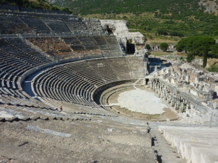
Theatre at Ephesus
Ephesus is of course now the big daddy of Turkish ruin sites, and is where we started a long day of ruin-hiking. Its position is not spectacular, unlike Pergamum or Priene, but its unique interest lies in its completeness as a city. It is the easiest of any Greco-Roman city to reconstruct in your mind how it was to be a citizen. From the car park the approach is along the Arcadian way, a colonnaded street paved with white marble, leading up from what was the new harbour before it again was silted up by the meandering stream of the River Meanderes. First to see is the huge theatre, well reconstructed, and just round the corner is the heart of downtown Ephesus. This, of course features the magnificent Library of Celsus, the best preserved structure of its kind in the world, painstakingly restored by Austrian archaeologists. The columns and capitals at its edges are smaller than those in the middle, creating an illusion of greater width. Tourists stand in awe. As in 1988, we chose to get there early and start our tour from the lower, harbour end of the city. Bus tourists are taken to the top end, and walk down through the city attended by their gabbling guides, a Babel of differing tongues. All this means that once again we had the magnificent centre of Ephesus just about to ourselves.
The Lonely Planet puts a sympathetic take on the Ephesus hordes, saying that they recreate the hustle and bustle of the working city it was. Well, I suppose so.
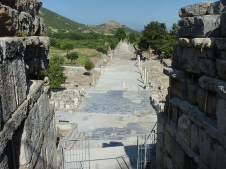
Colonnaded marble street to ancient harbour
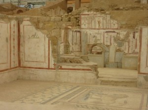
A part of the city which is now quite quiet is also close to the centre, but entry requires an additional (quite small) fee, which deters the groups. This area is completely covered by temporary roofing, which has been there a long time because it is overlies where most of today’s excavation is now taking place. What is being excavated and uncovered is a complex of town houses, ranging from a mansion with its own basilica, to an array of quite simple terrace houses. Walking round the complex as it ranges up the hillside is made simple by a system of glass walkways and good explanatory plaques. There are outstanding revelations of mosaic floors, painted walls, and central courtyards colonnaded in the Roman style. For this part of the city, it is alone worth the visit.
The rest is pretty well known from the guidebooks, and has not changed much in 25 years. Serious efforts at excavation appear to have ceased, and one collection of columns and statues does not even attempt to be a reconstruction of anything but is referred to as a “collage”.
When we returned to the lower car park, which been nearly empty when we arrived, it was packed with literally countless buses, all of which had deposited their charges at the top and who were still washing down the central arcades like a waterfall. Anyone who is thinking of visiting this outstanding ancient site is advised to do it our way!
The next site to be visited this day was Priene, reached on a series of main roads via Kusadasi and Soke. Kusadasi has never been anything other than a tourist resort, and has now become a nightmare of tasteless overdevelopment. By staying on the main road we bypassed the port and marina area, which hosts the cruise ships with Ephesus-bound passengers as well as those cruising yachts whose crews don’t mind this kind of thing. We passed through extended acres of enormous developments, including several multi-storey buildings on our way down to the city of Soke.
The excellent guidebook we used in 1988, and again this year, says that the drive south from Kusadasi to Soke passes through some of the loveliest Ionian landscapes. Well, once upon a time, maybe, but now it’s simply a long strip of combined industrial and tourist development. But finally there’s turn-off to the village of Gullubahce (“Rosy Garden”) and just beyond it, a climb up to the spectacular site of Priene. In the village we bought some bread – quite easy – but also meat, not so easy. It’s easy enough to choose a wrapped pack of meat in a supermarket, but not nearly so easy when the butcher opens a couple of fridges and points to some partly-butchered carcasses, especially when there is a complete linguistic barrier. Sign language got Norma a cut off one of the carcasses, which we assumed was beef. (It was, and was excellent when stir-fried later.)
Priene, apart from being in its lovely, cool and windy position, overlooked by an peaked summit and immense cliff face, was another change from Ephesus in that it was quiet. We shared it with barely a handful of others. It’s a fairly tough climb to the top, to its lovely little theatre and a partly reconstructed Temple of Athena. The temple, as it was, is regarded by experts as an archetypal Ionic temple, a house for the deity and not for common worship. The whole area is strewn with columns and building blocks, hardly changed from our previous visit (we checked the pictures). The most recent, and worst, damage to the temple was caused by an earthquake in 1955, one of the many earthquakes that have caused substantial destruction in the Aegean over the centuries. This was, and remains, a relatively modest Greek site, far from the Roman grandiosity of Ephesus.
Last site for the day was Miletos, once one of the greatest Ionian cities. As with Ephesus and Priene, the importance of Miletos was decimated by the retreating sea and the resultant loss of trade. The coastline is, indeed, still moving westwards. In early Ionian times Miletos was the greatest commercial city in the Greek world. The Ionians took over the site from Cretans and Carians in 1000 BC, and Herodotus tells us the Ionians slaughtered the entire male population and married the widows, having brought no women with them. The new wives thereafter refused ever to sit and eat with the men.
What you see on the approach is an enormous theatre rising from flat land. Its capacity was 15,000 people, and it is remarkably preserved, with vaulted passages at either end leading to the seats. Looking over the plains to the back of the theatre you can see scattered foundations and ruins near and far, and some greening of the scrubland shows where the harbour once lay. Again, we had the place pretty much to ourselves. It’s clear that Ephesus has so concentrated the interest of tourist organisations that it is only the few independent travellers who ever get to see these other places, all of outstanding interest in their own ways.
We were done with exploring in the heat, under clear blue skies, by this time, and with no clear idea of where we might end up, headed down to Didima and the sea. We came across what was claimed to be a camp site, but is now really an extensive parking and picnic area, obviously very popular with local people. For a small fee we joined them, and got settled under the shade of one of the scrubby trees all over the park, about 10 metres from the edge of the Aegean. We went for a refreshing swim – very refreshing – as we have always said, the Med is not warm enough to swim in until mid-July!
Tuesday 18 June
We slept to the sounds of the wavelets washing on the nearby shore, and woke again to a clear blue sky over the blue Aegean, with the temperature rising to the mid-thirties by mid-morning. Decided to stay for another night in this lovely, relaxing spot.
But it did get hotter and hotter, the hottest yet, relieved a bit by the wind, especially when some sea breeze was added to the unrelenting melem. But the swimming beach is very close, and the water was cool, and there were showers on the beach. We can see in the direction on Didima that there are resorts along the way, with chairs and umbrellas in rows, but this is a park and beach for local people, with large (in both senses) families packed into small cars. Many of the older and all the conservative women “swim” fully clothed, but the majority take a more western approach to the beach and a swim.
Joined by a small French van, youngish couple who are worrying just how much hotter it might get along the coast and when it might be better to cut inland. We are not worrying, but the same considerations are emerging. Is this just a heatwave or a trend?
Wednesday 19 June

Bodrum Castle, on the harbour
Clear and breezy again. Kate showed us the way to a Migros supermarket in Didim, and did some stocking up. Passed the Temple of Apollo that you’re supposed to see, but little there, except for one column. Then quite pleasant run through what looks like typical Turkish scenery in this region at least: scrubby trees and olive groves over reddish earth. Many of the road being substantially upgraded and resealed, but a fair bit to do yet! Good view over Lake Bafa, which is an interesting feature because it was a bit of sea, a long bay inland, that got nipped off by all the silting up and remains as a brackish but very pretty piece of scenery.
Pleasant approach to Bodrum from the north, overlooking the bays on the north side of the peninsula. Massed white development complexes on the surrounding hills and hilltops look like snow in the mountains. Then down into Zeta Camping, at the head of Gumbet Bay, just to the west of Bodrum. Here we once anchored our boat for several days after moving out of the commotion of Bodrum Harbour, in relative peace but extreme heat. I even had to treat a fellow yachtie for heat exhaustion, and we had the occasional swim during the night to cool off.
It was not quite as hot this time, settling in the mid-thirties. Found a slightly shady spot in the camp site, then after lunch and a swim in the rather murky water of Gumbet Bay took a minibus ride over the hill into Bodrum. We remember it as a touristy but pleasant town. It has morphed into a bustling metropolis, attracting a predominantly younger crowd, even less affected by the muezzin’s afternoon call to prayer than we have seen elsewhere. But building heights and developments in the town centre have been limited in scale, and it retains its soul. We walked around the harbour front, reminiscing about the days when we could anchor (with very many others, admittedly) in the middle of the harbour, where now two massive marinas have taken over the water, and the quay where simple tourist gullets used to moor stern to is taken up by much more palatial vessels – but still built of wood, beautifully varnished as ever.
Beach bar, Gumbet Bay
Minibus back to Gumbet, and the beachfront restaurant and club were in full swing, belting out very loud boom-boom music controlled by a jumping black DJ. Given the bright pink colour of all the furnishings and the prevalence of sleek young men of every colour, we thought it was probably our first exposure to a gay bar. We thought we’d never be able to sleep, but they switched off and closed down the club by about 7:00, so then quite peaceful. About 30 degrees in the van, no wind.
Thursday 20 June
Decided to take a loop round and drive west out along the Datcha peninsula, one of the two regions in southern Turkey of which we had become most fond in the boat. From Bodrum we had to do some backtracking, but along a good road in foothills with pleasant views. Down through Mugla and over something of a pass before descending steeply into Marmaris.
This is another place that has come from nothing to grow into a very popular tourist resort. Unlike Bodrum, which has restrained the heights of buildings and in other respects has tried to minimise the effects of mass tourism on its appearance and culture, Marmaris has had no such restraints. We bypassed it on another good road in the hills, taking a look down to the packed, large harbour and getting a glimpse of some bays in which we had anchored.
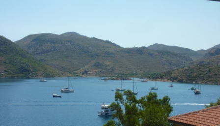
Bozburun Bay
Rather than going all the 70 km along to the end of the Datcha peninsula, we chose to deviate off it to the south and revisit Bozburun and its multitude of small islands and coves. We were among many other sailors who found these waters among our greatest favourites, and the presence of many cruising yachts in the anchorage off the town, as well as in coves along other shores, confirmed that this is still so. The town itself has grown, of course, and there are now lots of restaurants and touristy shops along the waterfront quay, but it’s still a low-key place. But while we enjoy visiting places where once long ago we sailed, it’s very much not the same, and we feel a bit wistful when we see the yachties walking ashore. Re-reading our logs of the time, we are reminded of the extraordinarily sociable life it was, with visits to and from other sailors, and much wine and many meals shared. We miss all that.
We had been intending to stay the night there, somewhere near the waterfront, and a French couple in a small van, who we had met in another fairly remote spot before, were intending to do so on the beach. But it was radiantly hot in the late afternoon, and we chose to go back to a parking spot owned by a family with a small restaurant at the head of a big bay, open to the west and very deep, and thus unattractive to yachts despite the pleasant surroundings. So we settled there, in some blessed shade, and had a couple of beers as the only customers of the restaurant.
Norma made friends with a goat on a tether right by the van, as she does with any animal, and a little dog that was also a member of the restaurant family. We carry a bag of dog biscuits, as her mission is to ensure that no animal goes hungry when she is around.
The countryside round here is very different from the coastal plains that we have driven along all the way from Gallipoli to Bodrum. In this volcanic far south-west corner of the country it has become jaggedly mountainous, with steep crags and cliffs, covered with dense pine rather than the scattered scrub of further north.
Friday 21 June
Quiet and peaceful night, and got quite cool in the early hours. 30 degrees again by 9:00 am, though. Substantial backtrack back up and out of the peninsula, but still a nice run among the old volcanic scenery, deeply indented inlets and little coves. Then south-east along the coastal plain and to Gocek, yet another part of a general aim we have of revisiting places we visited in Cera. Gocek was another of our favourites, with a small friendly village and a protected cove on the other side of the bigger bay. How things have changed! Turkey has gone aggressively into the yachting “market”, with big marina-building projects and other developments aimed at the burgeoning flotilla charter fleets and chartered large motor cruisers. This is probably to the disbenefit to the cost-conscious, self-sufficient independent cruiser, but it is hard to say from the shore. We do see a few foreign yachts anchored “out”, but they don’t appear to have increased in number since our time, that’s for sure.
Fethiye Bay
Anyway, all the protected parts of the shoreline of Gocek Bay are lined with marinas now, and the previously shambolic small town is now a shambolic larger town. But the bigger picture is still of a wonderfully attractive, green environment and clear water of all shades of bright blue. No wonder people still like to sail here now, as we did then.
Not far from there to Fethiye, an important regional centre, where we again stayed for some time in the boat. We then even wondered whether we should have come here for the winter of ’88-89, but on reflection Greece was a better decision.
Fethiye is a big town now, with substantial developments in the centre and for kilometres around in the suburbs. However, building height restrictions near the water have minimised the negative aspects of this growth. Nevertheless, the Lycian tombs that are carved into the walls of the cliff behind, which were once a dominant feature of the townscape, have lost their prominence to the glossy new hotels and the high masts of yachts in the big new marina.
For the night we had been recommended a stopover spot on the other side of the bay, where there are several old boat-building operations but little else on the wooded shore. This is where we anchored for a while, and where many cruisers do (or did) spend the winter. The place was a disused wharf and landing place with a view back over the bay to the town, an attractive prospect. But the only shade was from a small tree, and it got terribly hot during the late afternoon. It was also a scruffy place, with a couple of disused small buildings and the usual piles of rubbish everywhere. The Turkish people are among the world’s worst litterers, who strew their waste paper and plastic where they are and when they like. Children do the same, and are rarely if ever discouraged by their parents.
There were local visitors to the wharf during the day, but things quietened down until about 10:00 pm. We had just gone to bed when a couple of young men came down with a small car with what must have been the biggest sound system in Turkey. They proceeded to regale the whole bay with ear-bashingly loud Turkish music – not unpleasant music as it was, but at a volume that actually had an uncomfortably threatening feel from so close. To our huge relief they had had their fun by 00:30 and left us in peace, but this was the second time that we had felt uneasy in Turkey.
Saturday 22 June
We started the day with a steep drive up the hillsides behind Fethiye and across the fertile plain of the Kaya valley to the south, to the near-deserted village of Karakoy (previously Karmylassos in Greek, and Levissa before that).
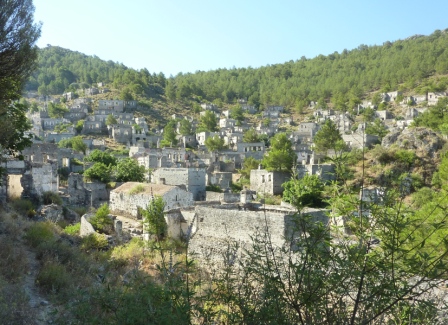
Deserted Levissa, de Berniere’s “Eskibahce”
The village is a stark reminder of one of the terrible outcomes of WW1 and the Turkish War of Independence. The Treaty of Lausanne encouraged a desire, through the League of Nations, to create unified nation states throughout the Aegean and Balkan regions. The agreement of the Greek and Turkish governments promoted massively disruptive population exchanges between the Greek and Turkish populations, creating great misery among the resettled and those who stayed alike. Levissa was a thriving Greek town, with good relationships between the main Christian Greeks and the Muslim Turks. When the Greeks were moved out (mostly to a new settlement near Athens, called Nea Levissa), the village was abandoned, and about 2,000 stone houses, plus two churches (one of each denomination) now stand derelict and abandoned.
The decision has been made to leave the village as it is by way of remembrance, and it now has UN World Heritage status on that basis. Not that you’d know; there were no other visitors besides us, and no apparent facilities for more, apart from a few tired-looking cafes. Maybe the Turkish people would prefer to forget this small example of the mass movements following the determination of permanent borders, movements that resulted in the deaths of millions of people after the fighting was all over. Not so many from this little village, perhaps; but those who were “marched” out with no assistance were all weak already from near starvation, were predominantly female, very old, very young, disabled in mind or body or very sick, and a few men who were not fit enough to fight. They were Christian Turks of Greek origin, speaking only Turkish, and those who managed to reach Greece were received with disdain or contempt. There were mass movements in both directions, affecting both populations and involving much mindless brutality from both sides. This was simply a microcosm of the whole affair.
The world-wide best-seller by Louis de Bernieres, Birds Without Wings, is a novel that follows the stories of several individual occupants of the village of Eskibahce, which is closely based on Levissa. In fact, while in the process of reading this book, it was eery to pass the village cemetery on the approach, appearing exactly as it is described in the book, quietly scattered among trees in a pine forest. The village is as he describes it, including a small white chapel high in the hillside behind. The novel covers the period from the turn of the century until 1923, including the Turkish role in WW1 (notably including some gruesomely descriptive accounts of the Gallipoli campaign) and the rise of Turkish nationalism. Mustafa Kemal figures strongly, with some amusingly acerbic comments that might not go down too well in these parts, where he is treated with god-like respect! I strongly recommend this outstanding book – albeit a massive read – to anyone interested in the history of WW1 and the region, or others who will anyway enjoy a good novel. The latter should read a bit about the history first, though. I first read the book several years ago without being familiar with the background, and it is a better read now.
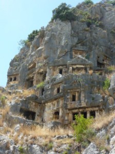
Lycian tombs, Myra
Our route then took us down out of the mountains to the coast, and along the mostly new and well-engineering road carved out of the steep slopes around the coast of Lycia. It’s a great run, very spectacular, passing round several tiny coves, steep to, with stony beaches that were very popular on this hot day. We stopped for swims at two of them, joined not only by beach-goers but also the passengers on a few gulets, the locally-built wooden cruise and charter vessels. We by-passed Kas, but had a lovely view over the port and offshore islands (including a Greek one), and then descended into the alluvial plains of the Calakir river. This is heavy tomato-growing territory, and it is big industry, with the valley almost covered by square kilometres of plastic greenhouses sheltering the plants.
This being Lycia, we had to see one of the most impressive collection of Lycian tombs. This is the ancient city of Myra, once a trading port but now 2-3 km inland. The most prominent feature of the site is a well-preserved Greco-Roman theatre, with most of the substantial stage buildings only uncovered relatively recently and some still being revealed. But the main reason to visit is to see the memorable honeycomb collection of Lycian tombs hewn into the cliffs behind the theatre. Burials were important to the ancient Lycians, and the tombs are scattered all over the countryside wherever there is a cliff face. They were displayed in a way that modelled domestic architecture, with a size and quality that matched the status of the deceased occupant. Many are faced with impressive, large columns and porticos under pitched roofs, and all glow pink in the sun.
In the late afternoon we dived down a steep road to a large waterfront parking and picnic place. On the way we passed through a narrow street packed with over 100 small pension/restaurants, most including “camping” (a space in the garden). The wide open space on the grassy sand suited us more, although shade was hard to find; then, in seeking some protection from the sun under one of the sparse trees, I stupidly got bogged in soft ungrassed sand. We got out after some digging and with the help of some anti-skid mats we were carrying for the first time. (The traction capacity of the front-wheel-drive Ducato van in slippery conditions is notorious.) Once again, a swim was welcome, although struggling through the pebbles was not like Mona Vale beach.
Sunday 23 June
Now we really had to get moving, as Turkey is a huge country and we still had a long way to go. We continued on up the coast, but it became more developed and industrial as we approached the big city of Antalya. Negotiating it was a nightmare (I’ll have more to say on driving in Turkey), but we avoided hitting anything or anybody and got to an outstanding museum, the Antalya Archaeological Museum. This is a true, and rather unexpected, jewel. It houses several beautifully=presented displays of objects from the earliest ages and eras, several coming from tombs and sarcophagi from the region.

Head of Apollo
Two breathtaking halls are devoted to marble statues of the Gods, crafted in the Roman era. Hercules, Apollo, Diana, Hermes – they’re all there. Many were originally placed in the stage buildings of theatres and in other public buildings, and were discovered during quite recent excavations of the nearby Roman city of Perge (of which there is little to see above ground). The statues and friezes are outstandingly well lit, giving them a presence rarely seen in conventional museums. Each one deserved a lengthy gaze.
Another dramatic hall housed a collection of sarcophagi, again in excellent condition, beautifully carved and lit. We liked a feature of the finest of these: the wealthy couple for whom they were being carved, in anticipation of their death, were represented as figures comfortably reclining on the cover of the tomb, accompanied in some by their favourite pet.
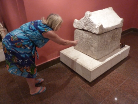
Sarcophagus for Stephanos the dog
An especially favoured pet was one who had a sarcophagus to himself, a dog named Stephanos owned by a rich and lonely woman in the 3rd century, Rhodope. An ancient Greek inscription on the tomb includes the words, “This grave keeps inside the one that death takes suddenly. This is the grave of the Dog Stephanos that went away and vanished. Rhodope cried for it and buried it like a human.”

Hercules
From Antalya we at last left the Aegean and Mediterranean coasts and headed due north inland, up to the plateaus of Anatolia, climbing up through the Taurus mountains to over 1,000 metres, with much higher mountaintops in the distance still striped with snow in the crevices. There are currently many large road-building projects in Turkey, the outcome being that where the roads are finished they are excellent, but also that we had to negotiate many kilometres of partly-finished roads and surfaces along the way. We drove up into the so-called Lake District, with some large fresh-water lakes fed by melting snow and many rivers (mostly dry now). We came to the town of Egirdir, on the shore of the eponymous lake, with little idea of where we would be staying the night; camp sites of any kind are few and far between, and campervans and motorhomes of any kind or nationality were nowhere to be seen. The most secure option appeared to be a car park in the lakefront in the middle of the town, overseen by an old man who supervised a car-washing business in a corner of the park and who also assured us not only that the area was covered by CCTV but also that he spent the night there.
Monday 24 June
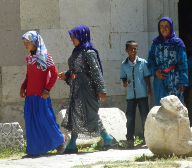
“Covered” women
It was indeed a peaceful night, and much cooler (to our relief) as a result of the altitude. After a quick walk round we set off on what was for us a long run, making easting on our way to Cappadocia. The road was what you might expect on a plateau, pretty much straight, with hills in the distance but not that interesting. There is substantial agriculture up there, however, with farms to the horizon on either side. The farms were very small by European standards, and the agricultural machinery also looked small and old-fashioned to our inexpert eyes. However, there were large grain and vegetable-processing centres along the way, so as a region, a lot is grown and sold.
Further east, past the important but dreary-looking town of Konya, the road continued arrow straight, with the flat plains and steppes looking more like a desert every kilometre. Several small villages were built mostly of mud houses, and from time to time we saw large gatherings of travellers in tarpaulin tents.
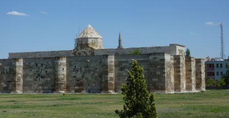
Sultanhani han, near Aksaray, Central Anatolia
We were planning to make a stop about half way, but a camp site we were aiming for in the town of Aksaray looked to be in a dusty and unattractive area. We were also approached by a tout trying to direct us there. But we had already decided to press on, having made good time, with only one building to see there: a famous “han”, or caravanserai. The Sultanhani han is one of the best preserved Seljuk caravanserais, built between 1226 and 1229 as one of a network to provide shelter, accommodation and storage for traders crossing Anatolia. The system expanded in Ottoman times and became an important factor in the expansion of the empire to the east. This example is a large building, looking a bit like a mosque from a distance, with a selection of covered and uncovered spaces, large and small. The largest storage hall has a barrel-vaulted ceiling and rows of aisles, and looks uncommonly like a church inside.
After Aksaray the road and environment got more interesting and varied, and finally we entered Cappadocia, the probable final extent eastwards of our tour of Turkey. Our first introduction to the extraordinary landscape of the region was dramatic: as we approached the little town of Ihlara we suddenly came across the kind of rock formation you see in all the promotional literature. This was a dwelling place for troglodytes living in the complex cave system, overlooking the Uchisar.
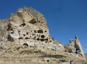
Troglodyte dwellings in the rocks above Uchisar village
We will see and do more here, but for our first evening we were pleased to settle into a tiny camp site, again associated with a pension and its restaurant. We were on our own, under the shade of a willow, beside a stream; Norma had ducks and chickens to talk to, and we had power (a cable down from the restaurant) and good wi-fi. We had beers and some meze in the restaurant, deciding that after a long day’s drive we would take the day off tomorrow.
Tuesday June 25
The only sounds during the night were from the vocal frogs in the stream. We are at nearly 1,300 metres, and it got quite cold: only 12 degrees in the van in the morning, but under a warming sun and blue skies. Norma did a spring clean of the van, and we caught up with Australian and world news, the emails, and this diary.
When approaching the village yesterday and around us now, we see many deserted stone houses, presumably once Greek and another result of the resettlement process of 1923-24. We were reminded of similar sights in Croatia last year, where Serbs had walked away as a result of pressures brought upon them by the Croatians.
Wednesday 26 June
Another cool start to the day, but mid-20s by 8:30. Further into Cappadocia, and our first visit of the day was to Derinkuyu, where lies of the several underground towns/cities in the area. It was a long, steep walk down steps to a series of hollowed-out caverns, which we were told were dwelling places, wine-making rooms and even a school. It was a right old maze of caverns and tunnels, and although we had declined the services of a guide because the way through was supposedly marked by arrows, we soon lost track of them and had to ask for help, even to get on up and out! The tunnels and other excavations are a bit like a large modern mine, in that they extend over several levels – although only two three muddled levels, down to about 100 metres, are open.
There is no indication, although doubtless it could be researched, of how the occupants managed with lighting, water and sanitation. It was all a bit weird and confusing, really, and the spaces were much smaller than we expected, for a “city”, not much more than two metres high anywhere, and rather claustrophobic. Yet this was supposed to be one of the bigger ones. Having emerged, Norma reckoned that we had now “done” underground cities.
There were a couple of camp sites we were thinking of for the night, both apparently well equipped, and from where we would book a flight in a balloon. But we needed some cash and Norma needed some basic stores, so after rejecting the first of the locations as being too far from anywhere we went on to Goreme, very much the centre of the Cappadocia tourist network. Approaching the town we had our first main sight of the amazing landscape and rock formations for which the region is so famous and, indeed, are the main reason why we have come all this way.
The rock formations of Cappadocia were created about 30 million years ago, when erupting volcanoes carpeted the area with ash. The ash solidified into an easily eroded material called, inappropriately, tuff. This was overlain in places by hard volcanic rock. The tuff then got partly worn away, leaving the columns, cones, pyramids and wavy rock formations of all colours that make the region unique.
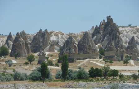
Rock formations, Cappadocia
An associated activity for which the region is also famous is the very popular ride in a hot-air balloon over this landscape, and in Goreme we booked for a flight tomorrow at dawn. We were impressed by the obviously expensive and attractive-look of the fit-out of the offices of Voyager Balloons. Also, because their “standard” and “comfort” flights were booked out for tomorrow, we were offered an upgrade to “de luxe” for the price of comfort, so took it.
Then up a steep hill 2-3 km out of the town to Kaya Camping, a great welcome from the friendly lady Turkish assistant manager, and took a position in a splendid location, high with an extended view over the jagged scenery. It gets windy during the day in these parts, and as we are high and looking into the wind, this helps to keep us cool. Also helping is an outstanding swimming pool, large and luxurious by camp site standards, so we enjoyed that too, usually by ourselves.
A disadvantage of the area, and a consequence of how it is eroding and reforming, is that it tends to be dusty, and the wind whips up the dust into williwaws, so that in time everything gets coated with a thin layer of fine dust.
Thursday 27 June
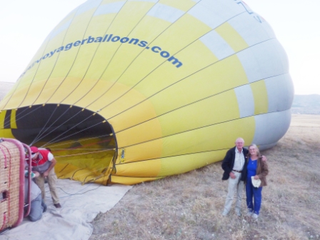 Alarm beeped early, and we were picked up by a Voyager minibus at the gates of the camp site promptly at 4:30 am. Beautiful, calm, clear morning. Into Goreme for a rather weird buffet breakfast, and then a minibus for us seven de luxe passengers (another pair of Australians and three Chinese) out to the take-off area. These are chosen day by day, depending on the local wind and forecast, to give the best chance of the best viewing. Hot-air balloons can only go where the wind blows, but to a limited extent the direction of the wind changes slightly with altitude, a characteristic the pilots take account of.
 We watched “our” balloon being inflated by the hot air from flames jetting from a burner, and slowly rising. Our pilot, Hazim, introduced himself. Voyager, like all the bigger balloon companies here, are all too conscious of the world-wide publicity given to the fatal collision of two balloons last year, and are very careful to emphasis the training, skills and qualifications of their pilots. Hazim’s aviation training was in San Diego, and he has been flying balloons for Voyager for three years. He was soon to demonstrate his skills.
A couple of days ago Norma had said, “I don’t know about this”, but the approaches to the enterprise and the professional air of the crews was easily enough to allay any fears, as we had read on several blogs and TripAdviser. Soon after the rising sun broke the horizon we eased away from the earth, so gently it was hardly apparent. 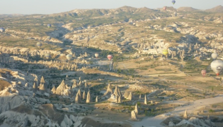 We then rose quite quickly, and joined the hundreds of other balloons gently sliding over the tortured landscape, rising with bursts of hot gas, or being allowed to fall gently as the air cools or is released through a vent controlled by the pilot. There is practically no air movement felt in the basket because the balloon is flying at the speed of the wind, but at lower altitudes the ground appears to be slipping past quite nicely. Hazim remains in radio contact with other pilots in the vicinity, with every one of them ensuring to maintain a safe separation.
We were very pleased to have fluked an upgrade, because with only seven passengers, the pilot and another crew member aboard, we had plenty of room to move and see all around. The “standard” flights have much bigger baskets but are packed with up to 30 people, which did not look comfortable.
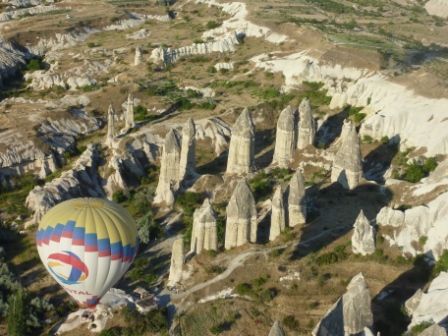
“Fairy chimneys”, as they are pleased to call them for tourists. Other descriptions are possible.
We also had a much longer flight, in the end lasting one and three-quarter hours, more than double the standard length. During this time we dipped into valleys with orchards, where Hazim manoeuvred so that we could pick apricots off a tree, and at other times soared to over 1,000 metres from the ground, which itself is 1,200 m above sea level here. We also enjoyed a glass of excellent Turkish bubbly.
The ground crew followed with a utility and trailer, in contact by radio with Hazim. Once he decided on a suitable landing area he informed the crew, and we could see them racing along dusty tracks to meet us. He descended slowly, and to our absolute amazement managed to land the basket on the bed of the trailer! Spontaneous applause followed. Considering that he has virtually no directional control, and even given that the driver of the tow truck can move along the track, as an ex-parachutist I regarded the manoeuvre as being of exceptional skill.
On final approach, for landing on trailer
The crew bundled up the deflating balloon and set up a table with more sparkling white, with a dash of cherry juice (very good), and the ladies were presented with flowers. We all got a “been there, done that” flight certificate, and were driven back to our hotels or, in our case, the camp site.
A balloon ride in Cappadocia is far from being a cheap outing, and for most family groups it is unaffordable. However, if you can stand the financial pain, it is an marvellous thing to do. As an advertisement for a completely different activity says, “the memories will last long after the price is forgotten”.
Not much could cap that for a day’s entertainment, but we did go for a walk in the afternoon. However, it was not a very long one because the camp is on the top of a steep hill, and having walked down, you have to get up again. However, we did descend into a part of the landscape that is a mass of swirly, high, white rocky masses, again unique. Then back for a swim, and a quiet evening.
Friday 28 June

Elmah church, Goreme Open-Air Museum
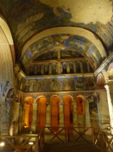
Frescoes in Tokah Kilise (church), Goreme
This morning’s activity was a very short drive down the hill towards Goreme and a visit to the nearby Open Air Museum, getting there as it opened to beat the crowds. This is another of Turkey’s World Heritage sites. It was originally an important Byzantine monastic settlement and later an important site for pilgrimage. It is a cluster of churches, monasteries and chapels cut into the cliffs and rocks. Many have open graves in them, and most have marvellous Christian frescoes, preserved exceptionally well because of the cool, dark, dry ambient conditions. They also escaped the worst of Muslim vandalism, although even in the most beautiful little church with the brightest paintings, as is typical the eyes of many figures have been scratched or obliterated.
Another restful afternoon in a cooling breeze under the van awning, reading more about Turkey and taking a swim or two in the large quiet pool.
Saturday 29 June
Away after three nights in this pleasant but dusty (like most other places here on the plateau) camp site, and quite good value too. Soon cleared the rock formations and into steppe country again, wide reaches of agricultural land with particularly extensive wheat fields. A surprising amount of industry, too, in and around the big towns of Kirsehir and Yerkoy.
Lunch stop in one of the only shady places along the way, in a grove of trees shared by a large herd of good-looking cattle using one of the many water troughs that are a regular feature of all the roads here. A small group of peasants was looking after them, and the woman among them, carrying a baby, came to the van and shyly offered us a drink of ayran. This is the traditional drink of Turkey (along with the highly alcoholic raki, which the PM would like to ban), and is made by mixing milk with yogurt and some water. What she offered had ice in it, although we couldn’t work out how they were carrying it, and the drink was very refreshing.
We returned the favour by giving the baby a little stuffed kookaburra (which they thought was a duck), and we had a glass of tea (cay, “chai”) with them. A pleasant encounter, with an absolute language barrier except for an exchange of names.
The cultural target for the day was the ancient Hittite capital city of Hattutas, built nearly 4,000 years ago. It is one of the most important ancient sites in Anatolia, a UNESCO World Heritage site, and the ruins of the city extend over a vast area which can be driven round on a one-way road. Several of the gates of the city are still in part standing, guarded by stone statues of lions, sphinxes and warriors. Houses would have been of wood and mud bricks, and what remains is mainly of hundreds of temples scattered over the hillsides, the whole surrounded by the remains of a city wall running along the ridges.
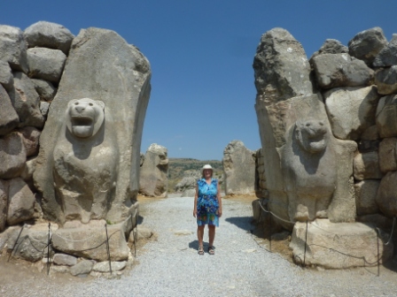
Lions Gate, in the walls of Hattutas
The Hittites were of Indo-European origin who arrived in Anatolia from the Caucasus around 2000 BC. They built up a powerful state, of which this place was the capital, and at one time controlled much of Anatolia as well as extending their influence into Europe and Syria. They were technologically advanced as carvers, stonemasons and metalworkers, and thousands of clay and bronze tablets discovered here have provided immense knowledge to scholars on this ancient civilisation. They were culturally advanced too, and apart from writing a coherent set of sensible laws they were cosignatories of the first ever written peace treaty, between the King of the Hittites and the Pharaoh of Egypt in 1285 BC. A copy of the clay tablet carrying the cuneiform script of the treaty is featured at the UN building in New York.
For the night we came to a simple but quite large camp site with clean new facilities attached to a hotel in the nearby little town of Bogazcale, by ourselves in what is actually an apricot orchard. Friendly welcome, and assured that we were welcome to all the apricots we could pick. Given several handfuls just in case. Ate at the hotel restaurant, mainly to support the local economy, not brilliant (meze and shish kebap with beer) but a pleasant evening.
Sunday 30 June
An unusual sight early morning: clouds, although very scattered and high white. Still by ourselves, and with a big black hose to hand, we took the opportunity to wash the van of the dust of the Anatolian plains before moving off.
For the first part of the run the feature was the frenetic activity in the farmland along the road, with heavy-duty harvesting of wheat and other crops. Later, there was more in the way of sunflower growing, we suspect something of a new endeavour here.
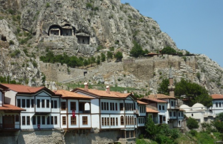
Still heading generally north towards the Black Sea coast we did something of a minor deviation to visit the town of Amasya. This has an exceptionally interesting history. It lies in a strategically important valley and is protected by cliffs and crags, on the top of one of which, overlooking the town, sits the citadel. It was an important town for the Hittites, then Alexander the Great took it as part of his eastwards expansion, then managed by Persian satraps (provincial governors) for Rome. Under Rome its importance grew, and it became the royal capital of the kingdom of Pontus. Cut into the cliffs over the town and under the citadel are several tombs that contained the graves of the Pontine kings. Four centuries of later Ottoman rule saw its further flowering, and it became a centre for Islamic study. In a medical complex established in the 14th century there was one of the world’s first centres for medical research, particularly into mental disorders.
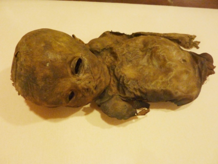 A river runs through the town, and during a hot afternoon we walked both banks, admiring the well-preserved Ottoman-style dwellings (most hotels now), with upper stories overhanging the northern riverside. Mosques, including some famous old ones, were abundant. We spent some time in the Amasya museum, recently refurbished, which includes a wide selection of mostly Ottoman artefacts. It is best known for its collection of mummies, found in Anatolia and dating from about the 14th century. Desiccated dark brown, unwrapped, they include men, women and children; with a trio being a local commander, his concubine, and their child.
From there to the sea it was a fairly easy run for the most part along a new dual-carriageway, dropping steadily down from the Anatolian plateau, without much traffic until we reached the outskirts of the huge port town of Samsun. Ataturk formulated his first plans for a Turkish republic here in 1919. Traffic was the usual nightmare for us, and having worked our way through the worst of it to the western outskirts we parked overlooking a small new harbour on the Black Sea. There appeared to be no more formal places to stay anywhere around.
Ottoman houses on the riverside, Amasya
Samsun is the furthest east we will be reaching in Turkey, about half way across the length of the country. Before coming, we had no real idea of how far towards the country’s eastern borders we would be going, and to travel that far would reveal some very interesting sights and history. However, there are considerations that have halted our further advance in that direction: the very long distances involved and the resultant high cost in very expensive fuel; and the lack of formal camp sites or suitable parking places. We are normally pretty relaxed about simply stopping for the night in free or wild “unofficial” spots, but here we are not that comfortable in doing so and we tend to trust our instincts. In addition, of course, there are eastern borders that today are unwise to approach too closely, and especially if one is wild camping.
We had a pleasant paseo along the brand new harbour front as the sun set, and watched the proceedings at the celebrations after a big local wedding not far away. We hoped for a reasonably quiet night.
Monday 1 July
Some hope! What with the music from the wedding continuing to 2:00 am, and lots of conversations from people walking and sitting nearby the van, and then being re-awoken by the muezzin’s call to prayer at 4:30 am, it was not that settled a night!
Early morning, although the rising sun shone from over the sea, it was soon covered by black clouds that were obviously dumping rain over the water. Quite a change from recent weeks! Still quite hot, at 28-30 degrees, but there was humidity in the air rather than the extreme dryness of the plains to the south.
Away at a relaxed pace and after clearing some industrial suburbs, over the hills and back to the sea at Yakakent. Good roads to this point, party of the highway to the east that the Turks are slowly building, but soon after, back to winding roads and lots and lots of roadworks. Still, a pleasant enough run, with views of the Black Sea, towards Sinop. The town seemed to be worth visiting, sitting as it does on its own little peninsula looking like an island, but it was far bigger than we thought and approached by a long length of dismal industrial suburbs, so we gave it a miss and turned west.
Black Sea coast
From there, the run became a succession of high crests through the woods, diving down to inlets at sea level, with views of the sea and forests. Several small villages, too, and all along the way lots of cows, donkeys and dogs wandering. The wind from the north picked up during the day, and by mid-afternoon was approaching gale force, with waves breaking over the sea walls of the waterfront towns. Rain, too, started off and on, and together with all the dust on the roads, and the regular bouts of roadbuilding, the van soon grew a layer of streamlined mud that put its recent wash to naught.
Our target was Cide, because of the certainty that it had a small camping place, but to get there turned out to be a much longer (in time) drive than anticipated, because the road was so tortuous, like a roller-coaster up and down and a tangled skein of wool laterally. Narrow, too, with far too fast oncoming traffic, not to speak of regular bursts of roadbuilding activity with trucks and earthmoving equipment; at one time, I was slowing to let a passenger minibus past when Norma said, “go, go now!” A truck had just dumped a load of huge rocks, and one was tumbling our way, not that I ever saw it.
On the final steep downhill approach to Cide, about 6:00 pm, we saw as we hoped a substantial harbour, which we preferred as a resting place to the small camp by a restaurant we had read about. We found a good place near the fishing boats and a large Black Sea cruise vessel, and were soon joined by a Turkish motorhome.
By this time it was blowing a full gale, and the rain – which had started a few hours earlier, off and on – had settled in. There was one cruising yacht in the harbour, a German boat with an experienced couple on board, but they were tied alongside the wharf with the gale blowing into the harbour, so that the yacht was bucking and rolling like a rodeo bull. We had told them earlier the story of how we had decided to get a camper one day, after seeing the vans ashore when we had been gale-bound in Greece. We thought they – especially her! – might have been thinking the same that evening! By 9:00 pm even our van was being rocked by the gale, with the crests of waves breaking over the sea wall and the rain driving down. We were pleased to be aboard our little tin box!
Tuesday 2 July

Cide harbour, rainswept in a storm
The rain and strong wind continued overnight, and as the swell built up outside, more and more waves crashed over the harbour wall. We were not close enough to be affected, but still got a coating of salty haze as the day continued.
We spent a quiet day, with the wind moderating but the swell breaking like Australian surf right across the harbour mouth. The rain contracted to showers, and there was a ray of sun about 5:00 pm.
Wednesday 3 July
Wind and rain died overnight, and it was generally blue skies by 8:30. Van filthy, but that will have to wait for a car wash facility unless we find a cooperative camp site.
Said good-bye to Norma’s doggie friends and away along the coast road again. Flat and easy to start with, but soon became again the switchback of steep climbs and descents over the crests of the coastal range. At the bottom of nearly all of the descents was a little harbour, most of which would be good stopping places for motorhomes. Through the many villages we saw, as is typical in Turkey, the women – often clearly old, stooped and frail – humping heavy loads on their backs while the menfolk grouped in cafes talking, playing backgammon and drinking cay. A pleasant drive scenically until we moved inland a bit via the industrial town of Bartin, then mile after mile of roadworks. Turkey will have a fine road system once it is finished. And that will be a while!
Back to the coast at Zonguldak, a coal port. We also saw several oil platforms well offshore, so it’s clear where much of the country’s energy is coming from. (Although they are building, or have built, the country’s second nuclear power station at Sinop, which we passed through a while ago.) Then through yet more roadbuilding to Eregli, once at least a major shipbuilding port, but from the number of rusting partly-built ships on the hard, not thriving.
Finally down to Akcakoca, where Norma’s research had found there were three camp sites. One was very expensive, and it turned out that the recommended one was closed. So we ended up at Camping Hamburg, welcomed (as you would be!) as probably the only visitors for some time. Very basic, a field next to a non-functioning pension, but with power and cheap, and an acceptable place for the night. Had excellent Spanish (tinned) sardines for dinner, because we couldn’t find a supermarket we could stop at on the way.
Walked down to the Black Sea “beach”, still a substantial surf rolling in, black sand absolutely filthy with debris. I mentioned earlier that the Turks were litterers – they are more than that. We stopped for lunch at a pull-in past Eregli, and it turned out that it was the local tip – rubbish simply dumped over the cliff into the sea. There are scores of such places along the coast.
Three weeks in Turkey is less than we had anticipated, so the debate now starts on where our travels will take us after we leave this country. Generally, we think, we’ll stick to plan 1 – which includes Serbia – but we will have a little more time in Europe than we thought.
A TRAVELLER’S NOTE ON TURKISH POLITICS
Far be it for a short-term traveller to represent himself as an expert on anything as complicated as politics in Turkey, but the sensitivities of the well-publicised situation in the cities and bigger provincial towns has caused me to read up on the present troubles and help to understand the historical context.
International interest as been drawn to the suppression of protests all over Turkey, which began as a peaceful sit-in in Istanbul to protect a small park from demolition and replacement by a large new building. In a dawn raid the police used violence that has been described by an eye-witness journalist and Istanbul resident, Claire Berlinski, as “disproportionate and sadistic”. It was also filmed and distributed by the ubiquitous social media, which set off more demonstrations throughout the country and in turn provoked “even more psychotic retaliation” from the police. In Taksim Square tear gas and rubber bullets were used, as well as “sound grenades” and water cannon. In two weeks four deaths and several brain injuries were confirmed, and ten people lost one or both eyes. Doctors are required to record the injuries as “accidental”, but Berlinski has seen hospital records confirming an extraordinary number of severe injuries that were clearly not so.
Things have now gone quiet, and Prime Minister Erdogan has been dealing with other matters overseas. I understand there is something of a carnival atmosphere in Taksim Square. But it seems probable that the carnival’s life might be short, if Erdogan continues to hold sway and promote the principles of sharia – hardly what was intended by the revered Ataturk.
Erdogan came to power in 2002, seeming to be what the world wanted: a Muslim version of a Christian Democracy. He became popular and successful, with major reforms in health and housing. The currency was stabilised and the economy grew. However, as commented by historian Norman Stone, Erdogan – instead of recognising differences and allowing dissenters to support who they choose – “an Islamic absolutism has taken hold”. There are puritanical restrictions on alcohol, including a ban on its sale in universities, pixellating drinks on TV and mandating warning labels. (And taxing wine so heavily that we cannot enjoy the excellent local product.)There are injunctions in the underground to “behave morally”. The internet is heavily censored. Some 800 journalists are now in prison on trumped-up charges. Lawyers supporting the protestors are also ending up in jail.
According to Stone, it is Arab money – primarily Saudi and Qatar – that has been supporting Erdogan and his economy, but that is now under threat because of Erdogan’s foolish involvement in Syria through support for the Syrian rebels. Stone believes that the Turkish President, Abdullah Gul, is uneasy with Erdogan’s actions, the Americans may be discreetly encouraging dissent, and that Erdogan may soon find that not everything is going his way. We will be leaving the country soon, but will continue to follow its affairs with great interest. That is one of the great joys of being a traveller, however inexpert.
Thursday 4 July
Much cooler last evening and overnight. The camp site was fringed with nut trees, and Norma was pleased to have identified a nuthatch in the morning morning. This is a major region for growing nuts and fruit, and we saw vast areas of raspberry plantations on the approach yesterday. A substantial proportion of all Europe’s raspberries are grown here, and as the first part of the drive showed, tons of nuts as well.
Quite a pleasant run to start with, over the hills through the nut, fruit and corn plantations, but then down to the plains at the eastern end of the Sea of Marmara. We stopped at a Carrefour’s for supplies, but the Carrefour here is nothing like in its native France, with poor stocking and gloomy, unhelpful staff. We had to go through a security gate even to get into the shopping centre, although Norma was waved through outside it and I passed despite giving out a loud “beep”.
And then began a long, slow, aggravating drag towards Istanbul. Turkish drivers can be bastards at times: they will never give way, at intersections, merging lanes, overtaking or at any other time, so when there is a slow-moving traffic jam – in which we were a part for over an hour and a half – there are endless possibilities for frustration, and the view ahead sometimes looked like the start of a Formula Ford race. The only way to handle this, and I did my incompetent best, is not to get emotionally involved.
Istanbul traffic is doomed, because the city lies on a quite narrow isthmus and all east-west traffic has to pass through this bottleneck.
We by-passed central Istanbul via the southern of the two bridges over the Bosporus, and finally got clear only for “Kate” (Tomtom) to get muddled over how we should leave the highway (the Turkish satnav mapping is new this year, and gets it wrong a lot) and finally get to our planned camp site, down on the coast of the Sea of Marmara. It was a scruffy place, packed with holiday-makers, as the kids are out of school for weeks, and because most of the pitches are permanent, there was not much room for us. We did get a space down at one end, with the major benefit of a good wi-fi signal. And it was cheap.
Clear and hot most of the day, and we blessed the van’s air-conditioning. As is happening now, the temperature drops fast by 8:00 pm. We will probably be across the border to Bulgaria tomorrow.
BULGARIA
More to come – stay tuned